|
|
|
|
|
|
|
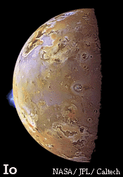 | |
| Big Mountain, Big Landslide on Jupiter's Moon, Io Written by Linda M.V. Martel Hawai'i Institute of Geophysics and Planetology Io, slightly larger than Earth's Moon, orbits 422,000 kilometers from Jupiter. Caught in a tug of war between the gravitational fields of Jupiter and the next moon out (Europa), Io is heated incessantly by tidal stresses. | |
|
Clear evidence of what this internal heat is doing to Io's surface was first revealed in the 1979 Voyager spacecraft images. Spectacular scenes of active volcanic eruption
plumes, a surface lacking any signs of impact craters,
and scattered mountains towering 10 kilometers above the yellowish plains make Io one of the most unusual and geologically active bodies in our Solar System. In fact, Io is so volcanically active that it is resurfaced at an average rate of 1 cm/year. This probably leads to recycling of the most deeply buried volcanic rocks. Photogeologic mapping by Gerald Schaber in the early 1980s showed three main units: smooth plains, vent-related materials, and mountain materials. While the plains and vent-related materials have been attributed to volcanic activity, Io's mountains may not be mere volcanoes and their origin remains a hot topic of research. Paul Schenk (Lunar and Planetary Institute) and Mark Bulmer (Center for Earth and Planetary Science, National Air and Space Museum) studied the geology of Io's prominent mountain Euboea Montes (47oS, 336oW). Their report in Science describes a detailed look at the shape of Euboea Montes and evidence for a landslide on it. Schenk and Bulmer consider the implications of their study on mountain formation on Io and the structure and stability of the crust. Their report is summarized below. | |
Stereoimages, two images that overlap one scene, acquired by the Voyager 1 spacecraft in 1979 were used by Schenk and Bulmer to map the mountain and its surroundings. The stereoimages, below, have resolutions of 1.6 and 0.8 kilometers/pixel and the scene width is about 550 kilometers. PSRD has superimposed labels and a north arrow on the left image based on Schenk and Bulmer's report. To view these images in stereo (3-D), geologists use a stereoscope: a frame holding two lenses above the stereoimages which, as you look through, focus each eye straight down onto the image below. The result is that the overlapped area is fused into one 3-D scene. In most cases, stereoscope lenses are magnified to increase vertical exaggeration for more depth perception. (Simple 3-D glasses with one red lens and one blue lens, will not work on these two images because they are simply shown here side by side and are not superimposed in red and blue colors. You could try seeing these images in stereo by allowing your eyes to cross -- in the same way as you view magic-eye 3-D images shown on the comics page.)

Click on the image pair for an enlargement.
![]() If you have red-blue 3-D glasses, then check out this 3-D anaglyph (image) of Euboea Montes created by P. Schenk, D. Gwynn, and J. Tutor for the 3-D Tour of the Solar System. Used with permission from the Lunar and Planetary Institute.
If you have red-blue 3-D glasses, then check out this 3-D anaglyph (image) of Euboea Montes created by P. Schenk, D. Gwynn, and J. Tutor for the 3-D Tour of the Solar System. Used with permission from the Lunar and Planetary Institute.
The Voyager images were used to make an elevation map using an automated computer program developed by P. Schenk and B. Fessler at the Lunar and Planetary Institute. The map allowed them to make height measurements. Euboea Montes is a football-shaped mountain (175 km by 240 km) about 40 kilometers east of Creidne Patera caldera. Schenk and Bulmer mapped a curved ridge crest (10.5 +/- 1 km at its highest point) which divides Euboea Montes into two sections: the steep, southern flank with an uneven surface of rounded mounds and the smoother, northern flank sloping about 6 oto the northwest. At the base of the northern flank is a thick, ridged deposit with rounded margins. Schenk and Bulmer saw no evidence for lava flows, vents, calderas, or any other volcanic features within this ridged deposit.
The shape of Euboea Montes, especially the northern flank's thick, ridged deposit, is interpreted by Schenk and Bulmer as evidence of slope failure along the entire face of the northern flank. They call the deposit at the base of the mountain a massive debris apron made by a rock and debris avalanche. Rocks moved down slope without water, trapped air, or hot volcanic gases. The estimated volume of the debris apron is about 25,000 km3. If this is true, then Euboea Montes has arguably the largest debris apron in the Solar System. Landslides in Valles Marineris or around Olympus Mons on Mars are also vying for the distinction as the "largest" as are submarine landslides on Earth. What triggered the collapse of an entire face of Euboea Montes and is it related to the formation of the mountain itself?
Origin of a Mountain on Io
Schenk and Bulmer used their observations of Voyager 1 stereoimages, measurements of heights on the digital elevation map generated from the stereoimages, and analogies to Earth structures to characterize Euboea Montes. Its relatively intact, polygonal shape suggests to them the mountain is one massive block of crustal material. The block was raised and tilted (by about 6 o) by thrust faulting. Consequently, this uplift initiated the massive landslide along the mountain's northern flank.
Schenk and Bulmer's scenario for the origin of Euboea Montes is directly tied to the idea of recycling of Io's crust. As layer upon layer of new volcanic material is erupted onto Io's changing surface, the older, buried layers are forced to subside. This old volcanic crustal material is compressed laterally as it sinks. Schenk and Bulmer think this global compression on Io is at least partially relieved by thrust faulting and uplift of large crustal blocks. Thrust faulting plays a similar role in some areas of regional compression on Earth where uplifted mountains are bordered on one side by thrust faults. (The Black Hills of South Dakota are an example.)
Euboea Montes may not be the only uplifted, exposed block of crust on Io. Schenk and Bulmer identified other mountains on Io with similar polygonal shapes, curved crests, and surface features. Uplift and rotation of crustal blocks may be a common mountain-building process on Io.
High-resolution images of Io planned by the Galileo mission in 1999 should reveal more details and help to test Schenk and Bulmer's conclusions.
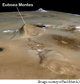
Left: This perspective view shows Euboea Montes, Io. Haemus Montes is seen in the background. Iopolis Planum is in the foreground. Vertical exaggeration is 4 times normal.
Below: Block diagram of the proposed subsurface structure under Euboea Montes. This sketch illustrates Schenk and Bulmer's idea that a thrust fault would be exposed along the southwest flank of Euboea Montes and dip steeply to the northwest beneath the mountain. Arrows show direction of movement. Layers of lava tilt slightly upward under the northern flank of the mountain.

![]()
![]()
[ About PSRD |
Archive |
Search |
Subscribe ]
[ Glossary |
General Resources |
Comments |
Top of page ]
1998
psrd@higp.hawaii.edu
main URL is http://www.psrd.hawaii.edu/