|
|
|
|
|
|
|
The Europa Scene in the Voyager-Galileo EraWritten by Linda M.V. MartelHawai'i Institute of Geophysics and Planetology |
|
Current Galileo Mission data are giving us the closest views of Jupiter's icy moon, Europa, since Voyager images first revealed the surface 20 years ago. The icy crust is smooth and blocky, with a banded and broken-puzzle appearance. Europa's outer shell, intriguing to geologists and astrobiologists alike, has been cited as evidence supporting a subsurface-ocean hypothesis. Two articles in a recent Galileo Mission special section of the Journal of Geophysical Research (Planets) review the water-ice surface, major geologic units, and the search for current geologic activity on Europa. Ronald Greeley (Arizona State University) and colleagues from universities, NASA, U. S. Geological Survey, and the National Optical Astronomy Observatories provide an extensive compilation of Europa's primary geologic units as a framework for further mapping of the surface. In another analysis of Galileo images, Cynthia Phillips of the University of Arizona (now at the SETI Institute) and colleagues from ASU, Brown, and JPL look for changes on the surface of Europa since Voyager. They also look for evidence of current geologic activity in the form of active plumes. Not finding proof of surface change and plumes, they give estimates of surface age and surface alteration rates on Europa.
Europa's Major Geologic Units
Europa's geologic history is written in its crisscrossed surface. The straight and curved bands and mottled bright and dark patches, looking like jig-saw-puzzle pieces out of place, tell a complicated story. Defining and characterizing the surface units is the first step in reading the geologic history of Europa's whole body, inside and out. Since the Voyager Mission, planetary scientists have divided the surface of Europa into general geologic units. Traditionally, a geologic unit is defined as a three-dimensional body of material (it has a thickness that extends below the surface) distinguished by its physical features and time of formation. Looking at images of Europa, planetary geologists have used surface shapes, textures, forms, layers, color, and relative brightness to define geologic units. The five primary terrain types now recognized in Galileo images of Europa are plains, chaos, band, ridge, and crater materials. Each unit's description and geologic interpretation, synthesized by Greeley and colleagues, are condensed in the table below. Image thumbprints are linked to pages in the NASA Planetary Photojournal with large-image downloading options (will open in a new window.)
| Image of unit (click to enlarge) | Name of unit | Description and interpretation |
 |
plains | Plains material is the most widespread surface type and is subdivided into ridged plains, smooth plains or simply, undifferentiated. The multiple ridges that make up the ridged plains have a variety of sizes, orientations, and crosscutting relationships. Smooth plains are generally dark and occur in circular to irregularly shaped areas. At global resolutions, as shown in the top of the image on the left, plains material is described as undifferentiated because ridges, which are probably there, or any other distinguishing feature simply cannot be detected. Many of the dark bands in this image are more than 1,600 km long. [NASA Planetary Photojournal #PIA00295.] Ridged plains are considered to be products of tectonic activity that squeezed, pulled, rafted, or broke the terrain. Ridged plains may have formed by multiple episodes or continuous ridge building, or by the opening and closing of fractures. Some ridged plains are the oldest recognized features on Europa. Smooth plains could be the result of a kind of "ice-water" volcanism where the fluid, erupted from below, floods a low-lying area. Most smooth plains appear to be among the youngest materials on Europa. Undifferentiated plains material probably consists of ridged and smooth plains materials, and possibly other units, that are not visible at global scales. |
 |
chaos | Platy, knobby, fractured, and rotated blocks of crust the size of several city blocks characterize chaos material. Some blocks of crust appear to be shifted and even tipped or partially submerged in a hummocky, textured background. [NASA Planetary Photojournal #PIA01403.] Chaos terrain is interpreted as broken pieces of preexisting materials that have been moved and disrupted by inferred internal activity. All current models suggest that chaos terrain formed directly above a heat source. Most chaos terrain is younger than ridged plains |
 |
band | Bands are linear, curved or wedge-shaped zones distinguished from the surrounding surface because of a contrast in albedo (or brightness.) Sometimes the margins look like bounding ramps or ridges. The interiors of bands are commonly higher than the adjacent terrain. [NASA Planetary Photojournal #PIA00291.] Bands probably formed when fractures initially split the crust and subsurface material moved up, filling the gaps. Repeated filling along a central spreading axis could account for the bilateral symmetry of features seen along some bands. Perhaps bands are the final stage in the evolution of ridges. |
 |
ridge | Ridges are topographic highs distinct from surrounding units. Ridges may be straight or curved, single, double (two ridges separated by a trough), or have more complex designs of curved sets of branching or joining segments. At global scales, ridge material is too narrow to map as a material unit but can be shown with symbols. [NASA Planetary Photojournal #PIA00849.] Several mechanisms have been proposed for ridge development. Over one Europan day, the moon stretches and compresses up to several tens of meters; this tidal flexing may lead to frictional heating and fracturing and movement of crustal materials. Ridges may be structures formed where underlying material broke through the crust along a fracture. They may also be debris piles from "ice-water" volcanism or places where the icy materials were squeezed and heaved upwards. |
 |
crater materials | Classification of crater materials is based on the clarity of rims and ejecta deposits. In some cases, remnants of impact structures are only recognized by the presence of concentric lineaments. Other features have well-preserved rims and continuous, finely-textured ejecta deposits. Still other features have well-defined rays. Pwyll crater, shown on the left [NASA Planetary Photojournal #PIA00586.], has a relatively sharp rim and well-defined ejecta deposits. Multiring impact structures (such as Tyre and Callanish) are further subdivided into smooth central, rough inner, and annular massif subunits. Crater materials are considered to be frozen melt formed by impact. Some ejecta may have been thrown out as a fluid. Rough surfaces may be collapsed sections of crater walls. |
Structural features on Europa mapped by the team include troughs, strike-slip faults, lineaments, depressions, and domes. All of these resulted from internal activity (tidally-driven tectonism and "ice-water" volcanism.)
What the Images Say About the Past
Based on their mapping of available Galileo data, planetary geologists have crafted a story of the origin and evolution of Europa's surface. In this story, extrusion of subsurface material onto the surface, tectonic processes (squeezing, pulling, sliding, breaking), and impact bombardment have sculpted Europa's icy crust. Ridged plains form the oldest recognizable unit on Europa. In the high-resolution images, most plains consist of complex networks of crosscutting ridges and ridge sets. The plains materials may represent the ultimate variety of upward, downward, and sideways movement of materials pushed, shoved, and broken across the surface of Europa. Areas of chaos terrain generally overlie the plains. Knobby and platy chaos materials look like broken pieces of pre-existing units. Chaos materials are generally considered to represent the surface expression of localized heat or subsurface activity, such as convection, intrusion by low-density material, or "ice-water" volcanism. Some high-standing blocks of knobby crust may indicate that some chaos terrain formed at the same time as, rather than after, ridged plains. Smooth plains are of limited extent, but seem to be some of the youngest materials on the surface. These could be small areas of local flooding. Impact craters are recognized on Europa, but are not numerous. They range from relatively old, low-relief structures to relatively young structures with well-preserved rims, continuous ejecta, and well-defined rays. While crater counts have been used on other planetary bodies to derive surface ages, the absolute timescale for the evolution of Europa remains in question until we can calibrate the rate at which impact craters form in the outer solar system. In any event, most researchers believe that all of the terrain types on Europa, even the oldest ones, are very young in geologic terms.
As people continue to work with the Galileo image data and gain more insight into Europa, the interpretations outlined above are subject to change. Current hypotheses for crustal formation generally assume that a liquid water ocean exists below a relatively young, icy shell. Some dark surface areas might be deposits of salty minerals such as sulfates and carbonates. [See PSRD article: Europa's Salty Surface.] If there is a hidden ocean, then is there current geologic activity on Europa? What kind of activity might we expect, and how might we see it? These are the questions asked by Cynthia Phillips and colleagues in their analyses of Galileo images.
What the Images Say About the Present
Phillips and her colleagues searched the Galileo images of Europa for what they say would be clear evidence of current geologic activity: active plumes of material venting from the surface or changes in surface features since the Voyager fly-bys.
Plumes
Plumes could develop on Europa if liquid water reaches the surface where it would boil in the vacuum of space and create a vapor cloud. Some people speculate that the plumes could reach heights up to 100 km if the gas content were high enough. Plumes of such heights would be detectable in Voyager or Galileo images, as already verified on Jupiter's moon, Io.
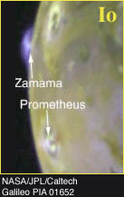 |
Plumes have been detected on Io. This Galileo image shows airborne plumes of gas and dust (about 100 km tall) from two of Io's active volcanoes. The umbrella-shaped plume from Zamama is on the bright limb. The plume from Prometheus is a bright, circular spot against Io's surface. |
Phillips and her coworkers turned their attention to images of the bright limb of Europa and of the moon in eclipse. They looked for plumes or any unusually bright, glowing surface regions. A series of images from Galileo orbit E19 (February 1999) was taken expressly to search for plumes, but the researchers saw no bright glows off the bright limb and no unusual, bright regions on the surface of Europa. Furthermore, they saw no evidence of plumes on the image of Europa in eclipse. A diffuse glow across almost the whole disk was seen, but was attributed to illumination by scattered light refracted through Jupiter's atmosphere. They conclude that there has been no observable plume activity during the Voyager-Galileo era and that it is unlikely plumes ever existed over the last few thousand years, otherwise their circular surface patterns would still be evident.
Surface Changes
The types of changes that could be detected on Europa include increases in height and width of ridges; formation of new surface cracks; new or larger pits, domes, and spots; new bright or dark deposits of ice or frost; or movement of crustal blocks by either rotation, tilting, submersion, or lateral displacement. Detection of all these possible changes is dependent on image resolution. Not only did the Voyager images have a lower spatial resolution, but also more geometric distortions than the Galileo images. Moreover, the researchers had to be careful to recognize true surface changes due to geologic activity and not be misled by changes in appearance created simply by the different viewing geometries, wavelengths, and illumination in the data sets.
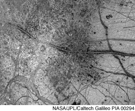 |
This Galileo image shows the variety of surface features on Europa having potential for showing changes: dark areas, bright areas, Belus Linea triple band, and the curving 'X' fracture (in the lower left) probably filled by slush which froze in place. An impact crater about 30 kilometers (18.5 miles) in diameter appears as a dark circle just left of center. It seems to have excavated into Europa's icy crust, throwing debris (seen as whitish material) across the surrounding terrain. The area shown is 860 by 700 kilometers (530 by 430 miles), or about the size of Oregon and Washington combined. |
To detect possible surface changes, the Voyager and Galileo data sets had to have similar ground coverage, resolutions, viewing geometries, and image wavelengths. Phillips and colleagues first identified overlapping pairs of Voyager and Galileo images and then relied on a comprehensive procedure of computer processing to calibrate and register the images. They used digital image processing techniques to adjust the images for geometric alignment and differences in camera attributes before creating a final ratio image. The ratio image, where the Galileo image is divided by the Voyager image, was inspected visually for surface changes. If nothing has changed, a ratio image will simply be gray because every feature has been exactly canceled out during the ratioing (division) process. Areas where the Galileo image is darker will be dark in the ratio, and areas which have brightened since Voyager will be bright. In general, any features that have changed in size, shape, location, or brightness over the 20-year interval between Voyager and Galileo will appear in the ratio image because they are not completely canceled out.
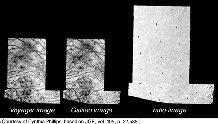 |
The Voyager and Galileo images have been adjusted, calibrated, and registered. The sharpness of the Galileo image was reduced to better match the lower-resolution Voyager image. Darker lines in the lower-right corner of the Galileo image show up because the area was very close to the terminator (the line of sunrise or sunset on the surface of the moon.) The ratio image is mostly gray, indicating a lack of surface changes. Darker lines in its lower-right corner are due to the difference in illumination between the Voyager and Galileo pictures. |
The ratio image was processed to bring out subtle structures in the otherwise flat gray appearance, yet it shows no substantial surface changes. Subtle bright lines that appear in the ratio image are attributed to changes in illumination between the Voyager and Galileo images. Changes in illumination of the surface topography or differences in angles between the pictures account for all the features seen in the ratio images. They conclude that there are no strong candidates for surface changes during the Voyager-Galileo era.
Implications of Results
The negative results of the plume search have interesting implications for the rates of erosion on Europa's surface. Expecting that plume deposits would likely be veneers of bright frost or dark dirty frost, researchers have tried to establish how quickly frost deposits wear away from Europa's surface. In one approach, they assume that micrometeorite bombardment mixes surface materials, much like a gardener tilling the soil. They also propose a microscopic erosional agent called sputtering, when low-energy ionized atoms from Jupiter's ionosphere strike Europa and drive off surface atoms, something akin to sandblasting with ions. Considering these two processes at work on the surface of Europa, researchers estimate that plume deposits would last about a few thousand years. A second approach focuses on the rays seen around the youngest, large impact craters on Europa because these rays probably contain frost. If plume deposits were similar in thickness (millimeters) and composition to crater rays, then they might fade at the same rate. Since the rays seen on three large impact craters (Pwyll, Manannan, and Teliesin) are estimated to be about 20 million years old, then the absence of recognizable plume deposits could mean that no large plumes ever formed over the last 20 million years. Does this mean that plume activity is ruled out entirely on Europa? The answer is no for at least four reasons: observed crater rays could be substantially thicker and simply last longer than potential plume deposits, plume activity could be rare, plume deposits could be so small that they have escaped discovery, or they exist in places not yet covered by any of the satellite images.
The lack of evidence of current or recent surface changes between the Voyager and Galileo images leads to estimates of a maximum surface alteration rate and a minimum surface age for Europa. The surface alteration rate is the rate at which the surface is noticeably changed or destroyed because of geologic activity. When looking for changes, the researchers were limited by the resolution of the Voyager images where a single pixel equals a site on the ground of 4 km2. Their images cover about 20% of Europa; so, the surface alteration rate, they argue, is 4 km2 over 20% of the surface over 20 years. Applying this rate to the entire surface they arrive at a maximum surface alteration rate for Europa of 1 km2 per year. Since the surface area of Europa is about 30 million square kilometers, a surface alteration rate of 1 km2 per year yields a minimum age for Europa's surface of about 30 million years. Is current geologic activity completely ruled out on Europa? The answer is maybe, maybe not. If geologic activity is happening now, it would have to be on a relatively small scale (below the camera resolution) or be episodic enough to have escaped notice.
 |
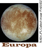
Icy Europa - Studying the Puzzle Europa, the sixth largest moon in the Solar System, is about 3,160 kilometers (1,950 miles) in diameter, or about the size of Earth's moon. Few other bodies are attracting as much scientific attention as Europa because of its possible subsurface ocean of water. |
| A special session on "Europa surface-subsurface material interchange, burial, and resurfacing processes" will be held March 15, 2001 during the Lunar and Planetary Science Conference in Houston. Europa's potential subsurface ocean is also very attractive to scientists searching for life elsewhere in the Solar System. The exchange of surface and subsurface materials may have important implications for future astrobiological studies. The next stage of Europa exploration includes the Europa Orbiter mission, planned for launch by the end of the decade. Its primary goals will be to gather global, high-resolution data that can be used to better define the ice crust and find conclusive evidence of a subsurface ocean in preparation for future surface and sub-surface missions. | |
![]()
|
|
[ About PSRD |
Archive |
Search |
Subscribe ] [ Glossary | General Resources | Comments | Top of page ] |